Rock Creek Falls, Rock Creek Recreation Area/Campground, Erwin, Tennessee.
Close, cool, and if you make it to the top... an incredible waterfall.
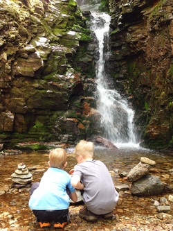
The Hike. The primary advantage of this hike is that it is a short, easy drive. The second advantage is that Rock Creek stays cool in the summer. It is a great place for kids on a hot day. Even if you don't do this hike or only do part of it, the creek and path that runs through the park make for a great summer outing including biking, rock throwing, salamander hunting, and napping, so bring a bike, a jar or bucket, water shoes, and a blanket! The hike itself starts at the end of the walk in tent sites camp area. Here is a map: http://www.fs.usda.gov/Internet/FSE_DOCUMENTS/stelprdb5275541.pdf. It's two uphill miles to a triple waterfall and if you get to the third and last, it is a fantastic place to hang out, throw some rocks, and explore. There are four water crossings and unless the water is running low, they are not super easy. We had to help our 6 and 9 year olds in a few places and they are usually gung-ho rock hoppers. A change of shoes or even clothes might be in order as well as plenty of snack and drinks because if you do make it to the top, you will be out for quite awhile (4 miles round trip with hanging out a few places was around 3 hours for us). There are some great places to play in the creek along the way and a nice looking swimming hole about 2/3 of the way up.
Directions. Take I-26 to Unicoi,exit 32. Go left off the ramp and right on 173 in Unicoi, heading toward Erwin. 173 becomes 107, which you should follow about 3-4 miles to Rock Creek Road or 395. Go left on Rock Creek Road, which will take you to the Recreation Area/Campground in a few miles on your left.
P.S. TAKE YOUR DOG!
